Mar 302020
 

The Vallejo Police Department cited ferry terrorism as part of its $30,000 grant application for license plate readers, calling the ferry “a viable threat for a terrorist act.”

According to the grant application, the “Grant Funds will be utilized to establish an ALPR [Automated License Plate Reader] camera system for eastbound and westbound traffic lanes approaching the Ferry Terminal, Ferry Terminal Parking Structure and waterfront.”

Two 3M ALPRs on Glen Cove Road in Vallejo
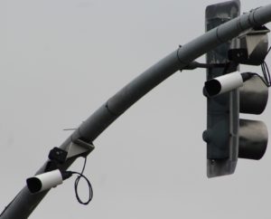
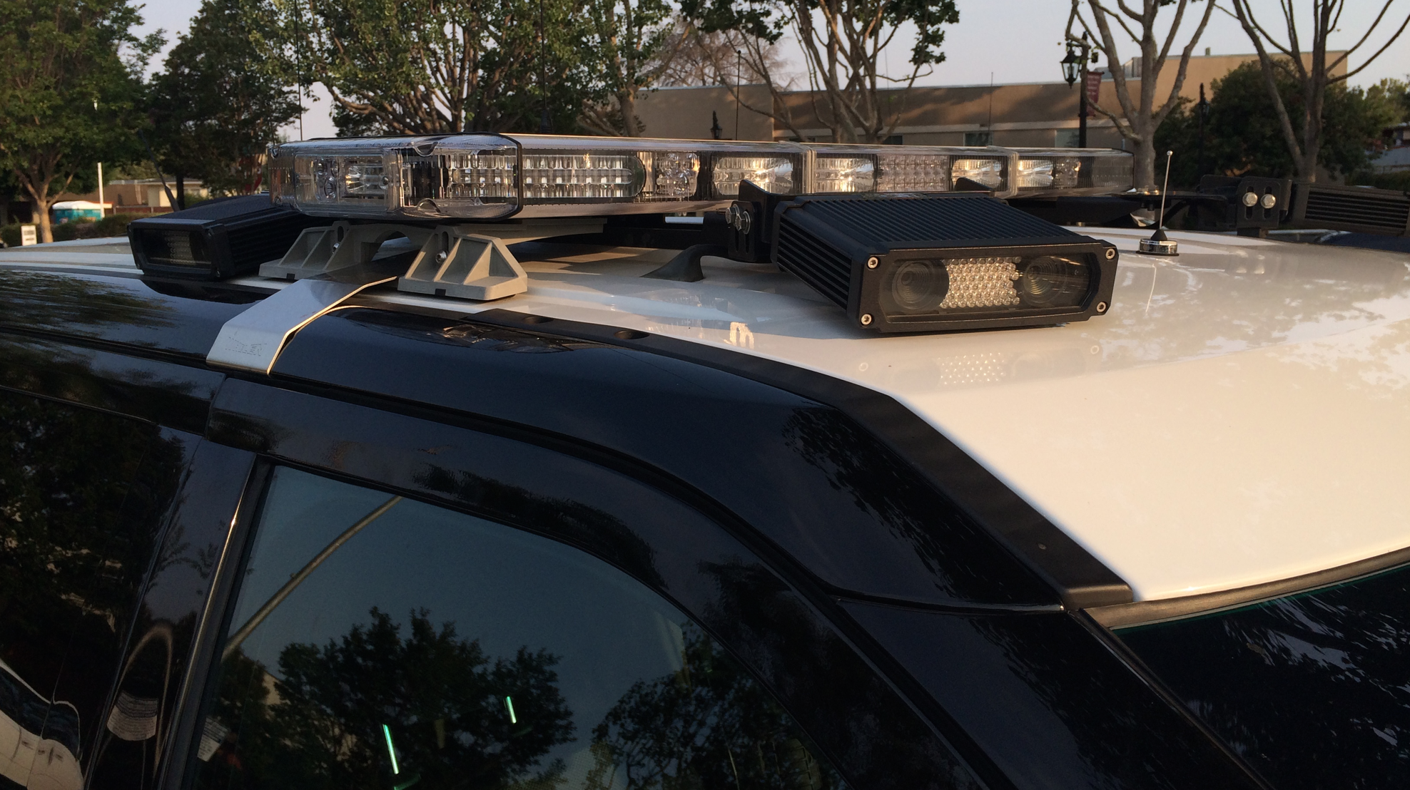
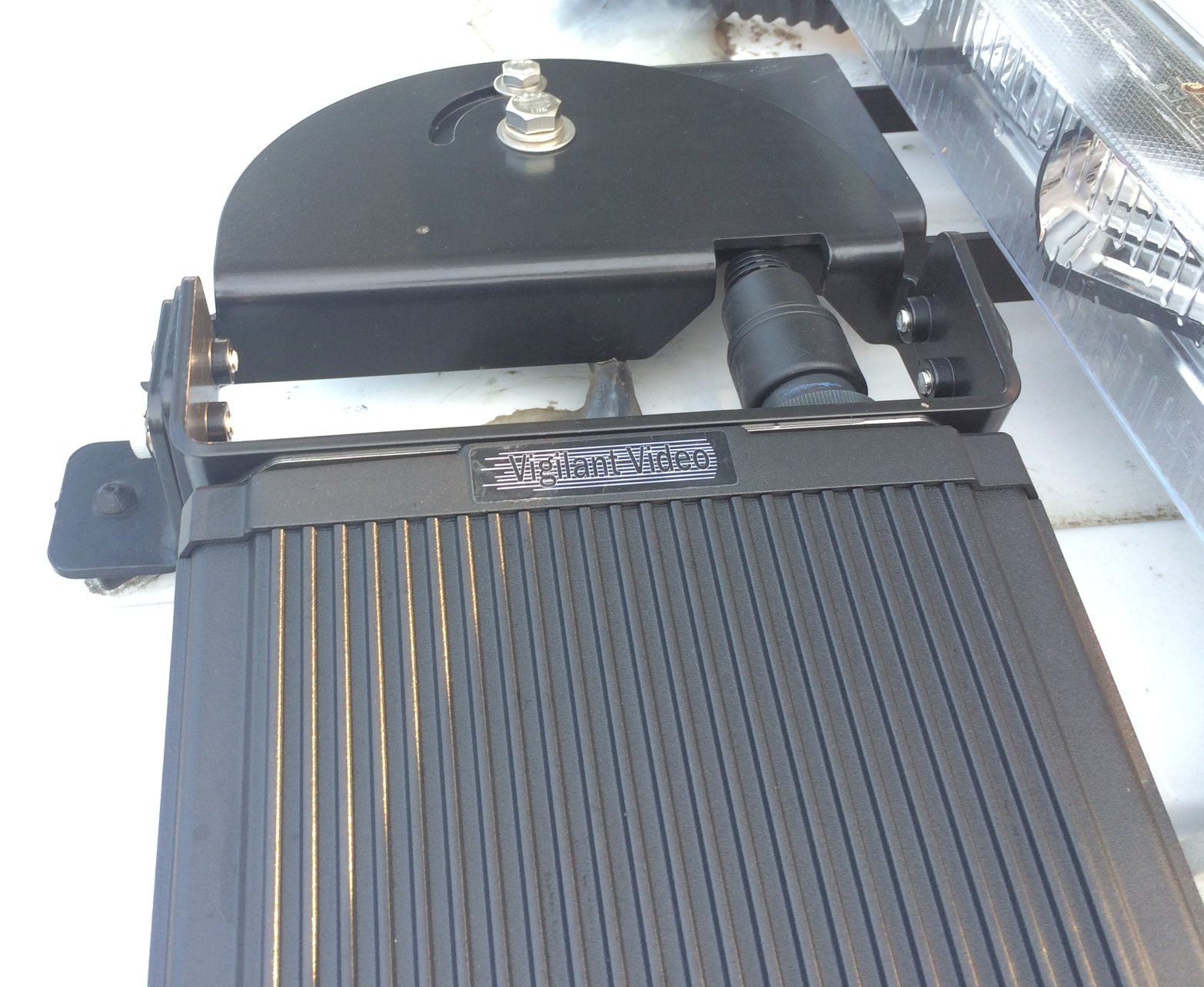
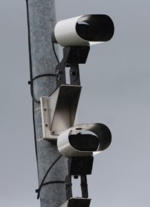
The Vallejo Police Department already has a network of license plate readers in locations around the city. Two of Vallejo’s ALPRs can be found on a pole on the west side of Glen Cove Road, at the Vallejo city line just south of Interstate 780. Two ALPRs are located in front of 4325 Sonoma Boulevard and two ALPRs are located on southbound Fairgrounds Drive at Gateway Drive. The six stationary ALPRs were installed in 2015, along with ALPRs on five police vehicles.

According to information provided to the California State Auditor, 102 of the police department’s 150 employees have access to license plate reader data. The Vallejo Police Department’s ALPRs send the collected images and data to the Northern California Regional Intelligence Center (NCRIC), which retains them for one year and makes it available to dozens of other agencies. In the six months from July 2019 to December 2019, Vallejo sent more than 5 million images collected from its ALPRs to NCRIC.

Vallejo Detective Lieutenant Fabian Rodriguez was listed as the applicant for the grant for the project, which was expected to begin on November 1, 2020 and completed by May 1, 2021.

The regional benefit was described as:

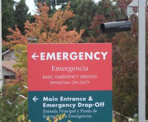
ALPR Cameras to Strengthen Information Sharing and Collaboration of data from Vallejo Ferry Terminal. The Ferry Terminal provides daily commuter transportation from Solano County to San Francisco, with commuters from Napa utilizing the ferry for daily transportation to the Bay Area.

The terrorism nexus was described as:

With thousands of commuters utilizing the Vallejo Ferry system each day to travel to San Francisco, the Ferry is a viable threat for a terrorist act. Installing an ALPR camera system in the area of the Ferry Terminal will assist with identifying potentially wanted terrorist suspect vehicles.

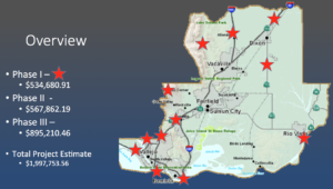
On March 12, 2020, the Bay Area UASI Approval Authority approved a $30,000 grant to the Vallejo Police Department for its “Vallejo PD ALPR” project. When we requested a copy of the grant application, the Vallejo Police Department responded that it has “no responsive documents.” The grant application was disclosed pursuant to a public records request to the Bay Area UASI.

Documents:

Jun 102018
 
3M P492 license plate readers on Fremont Bouldvard at Enea Terrace

License plate readers on Northbound Fremont Boulevard

According to data from the Northern California Regional Intelligence Center (NCRIC), the city of Fremont collected 14.5 million license plates and photos from license plate readers located throughout the city from December 2016 to October 2017.

The installation of stationary license plate readers was approved by the Fremont City Council on July 14, 2015, without any public comment or discussion during the meeting.

Of the 28 jurisdictions sending license plate reader data to NCRIC, Fremont collects the third-highest amount of data, behind Vallejo (21.7 million) and Piedmont (21.3 million). NCRIC is a regional fusion center that provides a license plate database where agencies can send their collected data. Other agencies, including the IRS, Department of Homeland Security, FBI, National Park Service, California Department of Insurance and others can access this database and search for license plate data.

The license plate reader on westbound Stevenson Boulevard near the entrance to northbound Interstate 880 generates the most data, collecting an average of 14,736 license plates and photographs each day during October 2017.

Although similar statistics are not available for Fremont, analysis of license plate reader data from other jurisdictions has found that 99.7% of the data collected by license plate readers is of people not suspected of or charged with any crime. For Fremont, that means 14,519,834 of the 14,563,525 photos and license plates collected during an 11-month period was of innocent people.

Click here for a map showing license plate reader locations and links to Google Street View images:

Eastbound Auto Mall Parkway at Christy (1): Google Street View

Westbound Mowry Avenue at entrance to Northbound 880 (1): Google Street View

Westbound Decoto Road at entrance to Northbound 880 (1): Google Street View

Southbound Ardenwood Boulevard to Westbound 84 (1): Google Street View

Westbound Stevenson Boulevard at entrance to Northbound 880 (1): Google Street View

Northbound Mission Boulevard at Washington Blvd (1): Google Street View

Southbound Mission Boulevard at Paseo Padre Parkway (2): Google Street View

Northbound Fremont Boulevard at Enea Terrace (2): Google Street View

Camera operated by Pacific Commons Shopping Center at Northbound Christy Street south of Auto Mall Parkway (1): Google Street View

Source documents:

NCRIC ALPR data from December 2016 to October 2017
NCRIC ALPR data from October 2017 to July 2018

Nov 222017
 

The Center for Human Rights and Privacy recently discovered that the Alameda County Sheriff installed a license plate reader at the entrance to Highland Hospital’s emergency room. The information was included in a list of 29 agencies that submit license plate reader to the Northern California Regional Intelligence Center (NCRIC), a local joint fusion center.

However, when the East Bay Times asked about its license plate readers in February 2017, the Alameda County Sheriff’s Office reported that it had about six license plate readers, mounted to patrol cars and didn’t mention the license plate reader at Highland Hospital.

Although the license plate reader was installed as part of an Alameda County General Services Agency project, it appears that the Alameda County Sheriff configured the license plate reader to send its images and data to NCRIC. The Alameda County Sheriff signed a Memorandum of Understanding with NCRIC in October 2014 regarding license plate reader data. According to NCRIC, the Alameda County General Services Agency did not have a MOU with NCRIC as of November 20, 2017.

The license plate reader has two cameras to capture images of vehicles and license plates as vehicles enter the emergency room drop-off area of Highland Hospital from E. 31st Street.

According to information from NCRIC, the license plate reader captured data from 293,148 vehicles from December 2016 to October 2017. Earlier data was not available. Once the information is submitted to NCRIC, it is made available to dozens of agencies, including Immigration and Customs Enforcement (ICE) and Homeland Security Investigations (HSI), which can use it to identify undocumented immigrants for deportation.

The license plate reader was installed as part of a project to replace the Acute Tower at Highland Hospital in 2014. According to a change order for the project, installation of the license plate reader cost $74,622. The license plate reader is from 3M and was previously known as the SpikeHD P382.

In addition to the photos below, the license plate reader can be seen in Google’s Street View.

Alameda Co. Sheriff license plate reader at Highland Hospital


Closeup of Alameda Co Sheriff license plate reader at Highland Hospital in Oakland

Coverage in the East Bay Express: Highland Hospital Surveillance Stirs Concerns

Aug 052017
 

With a nod to Terminator’s self-aware computer network, the Solano County Sheriff in Northern California has applied for and received partial funding for Project Skynet, a network of surveillance cameras and automated license plate readers (ALPRs). Project Skynet would install 160 ALPRs and 124 surveillance cameras at 66 locations throughout Solano County. In its response to a request for public records, Daniel Wolk, Deputy County Counsel for Solano County noted, “this is at the proposal stage and specifics, including camera locations, have not been decided upon.”

Map of Phase I Camera/ALPR Locations

Map of Phase I Camera/ALPR Locations

Like the ring of stationary ALPRs around the City of Piedmont, the goal of the project is to capture images and video of all vehicles entering and exiting Solano County. According to a Microsoft PowerPoint presentation prepared by the Solano County Sheriff’s Office, the surveillance cameras would be capable of pan-tilt-zoom and data from the ALPRs and cameras would allow “real time information or years of past history.” The UASI grant application states, “In addition to the direct connection this project has with observing and locating terrorists, it also allows law enforcement to monitor human trafficking. I-80 is a major artery for drugs and human trafficking which are major funding sources for terrorism, from the west coast to the east.”

As with all grant applications to the Urban Areas Security Initiative, the project must have a nexus to terrorism. In its proposal for a Homeland Security Grant, the Solano County Sheriff writes, “We will be able to…locate persons and vehicles associated with terrorist threats, disrupt terrorist financing…” However, given that terrorism is extremely rare, this surveillance network is more likely to be used against pedestrian suspected criminal activity.

The PowerPoint document states, “There are 36 (666) locations, many of which are large freeways and near impossible to watch at once.” “666” is a police code for a county-wide emergency or be-on-the-lookout (BOLO). However, the grant application and approval documents cite 35 locations.

On July 13, 2017, the Bay Area Urban Areas Security Initiative (UASI) Approval Authority approved funding of $104,590 towards the $2 million total cost of Project Skynet.

Bay Area UASI Approval slide

The estimated $2 million cost for Project Skynet is broken down into phases with an estimated cost of $535,000 for Phase I, $568,000 for Phase II, and $895,000 for Phase III. Data from the ALPRs would be stored at the Northern California Regional Intelligence Center (NCRIC), the local joint fusion center that shares license plate reader data with dozens of local, state, and federal agencies.

The NCRIC stores license plate reader data for dozens of local law enforcement agencies and as of April 2015, stored 46.5 million records, which includes license plates and photographs of vehicles, including the occupants and surrounding area with geolocation data.

May 132016
 

Three stationary license plate cameras were recently installed on East Sir Francis Drake Boulevard in Larkpur as part of a Regional Automated License Plate Regional Network (also called strategy and strategic plan) supported by the Northern California Regional Intelligence Center (NCRIC) and funding from the Bay Area Urban Areas Security Initiative. The cameras record images of vehicles and license plates traveling in each direction along East Sir Francisco Drake Boulevard near the intersection with Larkspur Landing Circle.

The Central Marin Police Authority (CMPA) applied for the $132,553.96 Fiscal Year 2014 grant as part of a Regional Automated License Plate Reader (ALPR) Plan. According to the application, “This project is intended to address the roving criminals and possible terrorist operating in the Bay Area…” In highlighting the large number of license plates that could be photographed, the application states, “This location has the potential of capturing and identifying at least 20 million license plates a year as a corridor between US Route 101 and Interstate 580…” However, in its ALPR Proposal slide deck, the Central Marin Police Authority noted that a CalTrans survey from 2010/2011 showed just 4,865,546 vehicles passing this location each day. This discrepancy is not explained in any of the available documents.

The grant application noted that an automated license plate reader trailer from the NCRIC was placed at 135 E. Sir Francis Drake Boulevard from June 17, 2011, to July 25, 2011. During that time, 22 stolen vehicles reportedly drove past the ALPR trailer.

A May 16, 2014, memo of the Bay Area UASI Advisory Group, stated, “During the February Advisory Group FY14 Regional Project vetting session, a Regional ALPR strategy was supported, however the majority felt the CPMA project was not optimal due to the location.” However, by May, the Advisory Group recommended that the project go forward: “The ALPR Focus Group is again making a recommendation that the Advisory Group consider allowing the UASI Management Team to direct the allocated FY14 funding to proceed with the CMPA ALPR project as the first step in building our Regional ALPR network.”

The Larkspur City Council unanimously approved funding for the purchase and installation of the three license plate readers at its meeting of December 17, 2014, without any public comment.

The data collected by the license plate readers will be stored in the NCRIC’s ALPR data warehouse for one year. NCRIC Director Mike Sena said in April 2015 that 46.5 million records were collected from agencies submitting data to its ALPR data warehouse. NCRIC currently collects license plate data from about 20 law enforcement agencies.

The cameras are visible in this Google Street Maps image from October 2015.

Photos of the installed cameras:

Three automated license plate readers on E. Sir Francisco Drake Blvd in Larkspur

Three automated license plate readers on E. Sir Francisco Drake Blvd in Larkspur

Closeup of three automated license plate readers on E. Sir Francisco Drake Blvd in Larkspur

Closeup of three automated license plate readers on E. Sir Francisco Drake Blvd in Larkspur

Source documents:


Apr 052016
 

The Northern California Regional Intelligence Center (NRCIC), the fusion center for Northern California, has three trailers with automated license plate readers that it loans out to other agencies.

The trailers are intended to look like speed limit warning signs that prominently display the speed of passing cars but are equipped with cameras that capture images of vehicles passing in both directions.

Trailer used by NCRIC to capture license plate and vehicle images

Trailer used by NCRIC to capture license plate and vehicle images

The NCRIC is managed by the San Mateo County Sheriff’s Office, which handles requests for the trailers. The trailer picture was deployed in front of Willard Middle School in Berkeley in October 2015 after a series of attempted kidnappings.

The trailers and their deployment by a covert equipment crew is described as follows in an email exchange with NCRIC (emphasis added):

NCRIC has [redacted] portable ALPR trailers that look like speed signs and function that way as well, they are solar powered but if they can be placed near an alternate power source they will of course last longer than the average 5 at period, bottom line I they are available but very often loaned out to other agencies for similar reasons that you require one. Once approval is obtained on your end please let Sean O’Donnell or I know and we can enter your request on the NCRIC website for this equipment on your behalf etc, just let us know we’re here to help: Once approval is obtained as you mentioned, we can easily facilitate the placement of ALPR trailers with our NCRIC covert equipment crew, no problem.

As of January 2016, NCRIC had three trailers, which are referred to as PIPS LPR Speed Trailer #1, PIPS LPR Speed Trailer #2, and PIPS LPR Speed Trailer #3.

Requests for the ALPR trailers are submitted via NCRIC’s web site and then sent via email to NCRIC with the subject “NCHIDTA Equipment Request.” NCHIDTA is the abbreviation for Northern California High Intensity Drug Trafficking Area, which is also managed by the San Mateo County Sheriff’s Office.

Agency Date of Request Requested For
San Francisco Police June 16, 2015 Five days beginning on June 25, 2015
National Park Service June 17, 2015 One month beginning on June 24, 2015
Santa Clara Sheriff’s Office August 5, 2015 One week beginning on August 5, 2015
San Mateo Police Department September 1, 2015 As soon as possible for unknown period of time
Burlingame Police Department November 3, 2015 Two days beginning on December 16, 2015
San Bruno Police Department November 4, 2015 One week beginning on November 5, 2015
San Mateo County Sheriff November 5, 2015 One week beginning on November 10, 2015
Burlingame Police Department November 6, 2015 Five days beginning on November 23, 2015
San Mateo County Sheriff December 16, 2015 One to two weeks beginning on December 21, 2015

However, the information released by NCRIC did not include any information as to whether an ALPR trailer was actually deployed. For example, the National Park Service requested an ALPR trailer, but it was never deployed.

Technical Details

The trailer can operate on battery power for up to 5 days and takes 24 hours to full recharge. There are four cameras in two housings that can capture images of vehicles and license plates coming towards the trailer and going away from the trailer. The cameras are manufactured by PIPS Technologies, which is now owned by 3M. The cameras are surrounded by infrared LEDs that operate in the infrared spectrum at 950nm 3M_P634-Camera. A Garmin GPS is used to provide the geographic location data (latitude and longitude) that is stored with each of the images captured by the cameras. The data is uploaded via a cellular data connection to the NCRIC’s ALPR data warehouse, which had 46.5 million records as of April 2015 (see Who’s watching who?: License plate readers used throughout San Mateo County).

Source documents:

Emails between NCRIC and law enforcement agencies

License Plate Reader Data Sharing at Northern California Regional Intelligence Center


Shortly after Palantir’s successful bid, the Northern California Regional Intelligence Center (NCRIC) began gathering and sharing license plate reader data from law enforcement agencies throughout Northern California.

Fifteen agencies have a signed Memorandum of Understanding with NCRIC to share license plate reader data:

Sep 072015
 

In 2013, the City of Piedmont, California, spent almost $600,000 to purchase 39 license plate readers covering most of its border with Oakland. With a population of less than 11,000 people, these 39 license plate readers collect photographs and license plates from more than 1,000,000 vehicles every month. The City of Piedmont sends this data to a regional license plate data warehouse at the Northern California Regional Intelligence Center (NCRIC), where it is stored for one year, even if the data does not generate a “hit” as a stolen vehicle, being registered to a wanted individual, etc.

The City of Oakland, with a population of more than 400,000 people, took three years to gather 4.6 million license plate reads and photographs (see We know where you’ve been: Ars acquires 4.6M license plate scans from the cops). In Piedmont, that same amount of data would be collected in less than 5 months.

Using the information gathered by Oakland’s license plate readers, Ars Technica was able to determine where Oakland City Councilmember Dan Kalb worked and lived with his vehicle captured just 51 times between May 2012 and May 2014. Data from license plate readers could reveal churchgoing habits, whether you visit a medical marijuana dispensary or a health clinic, and whether you spend the night with someone other than your spouse.

Until June 2014, NCRIC generated a report on total license plate reads submitted to it by each agency. Combined with the number of hits reported by the Piedmont Police Department, this data shows that 99.97% of the data collected by Piedmont’s license plate readers is useless – it is data collected about people who are not charged with or suspected of any crime. For example, in April 2014, Piedmont submitted 1,420,244 license plate reads and photographs to NCRIC and only generated 400 hits. That is a hit rate of 0.00028 or 0.028 percent. Below is a table showing this information from December 2013 to June 2014:

Month Total reads Hits Percentage
12/2013 1272871 532 0.042
1/2014 1201196 374 0.031
2/2014 1025771 276 0.027
3/2014 1189422 323 0.027
4/2014 1420244 400 0.028
5/2014 1462313 465 0.032
6/2014 1213121 391 0.032


Source documents:


Sep 012015
 

According to documents from the California Highway Patrol (CHP), it has purchased 216 Vigilant Video license plate readers between June 2011 and April 2015. In addition, an undated document on automated license plate reader statistics indicates that there were 86,899 alerts for 27,545,659 license plate reads, a hit percentage of 0.3%. In other words, 99.7% of the data gathered by the CHP’s license plate readers was essentially mass surveillance on people not suspected of or charged with a crime.

The license plate readers were purchased using homeland security funds in batches of 120 on June 30, 2011, 73 on February 13, 2012, and 23 on March 9, 2012. The bid specifications are dated June 27, 2011, and the contract was from February 6, 2012, to February 5, 2015. The total cost of the license plate readers was just over $2 million ($2,050,644.01).

Section 2413(b) of the California Vehicle Code states, “The Department of the California Highway Patrol may retain license plate data captured by a license plate reader (LPR) for no more than 60 days, except in circumstances when the data is being used as evidence or for all felonies being investigated, including, but not limited to, auto theft, homicides, kidnaping, burglaries, elder and juvenile abductions, Amber Alerts, and Blue Alerts.”

Here are some photos of the Vigilant Video license plate readers mounted on a CHP Ford Explorer:

CHP_ALPR_Explorer

CHP Ford Explorer with Vigilant Video license plate readers

CHP_ALPR1

CHP Ford Explorer with Vigilant Video license plate readers

CHP_ALPR_top

Top view of Vigilant Video license plate reader mounted on CHP Ford Explorer.

Source documents: